IIRC the Cessna book I used years ago covered that well. I did self-study and don't recall having any issues.
First thing I'd do is understand each airspace type and what it's rules are. Understand that well. Only then look at the charts, they will make more sense if you thoroughly understand the airspace.
Plant city (PCM) is in the 100/30 boundary, so yes the B there is between 10K and 3000. Below 3K is under the B shelf, so some additional rules apply there as well. PCM is surrounded by a shaded magenta boundary, that's the class E down to 700 AGL (which is merged with the class E from other nearby small airports.
The boundary south of PCM is for a 100/60 shelf.
Lakeland is outside the B, but within the 30 mile mode C circle.
KSRQ to the south is outside the B because it's class C and has a circular carve-out from the B.
Don't confuse the light blue victor airways with darker blue B boundaries. Also the boundary colors aren't very consistent, you always have to look at the color AND the width and shading of boundary lines. There's a lot of magenta around SRQ...
Thick solid class C
Thin solid mode C veil
Thick shaded class E 700 AFL
Thin solid with dots ADIZ
Thin dashed isogonic line (mag variation, 5 degrees)
 AIRLINE
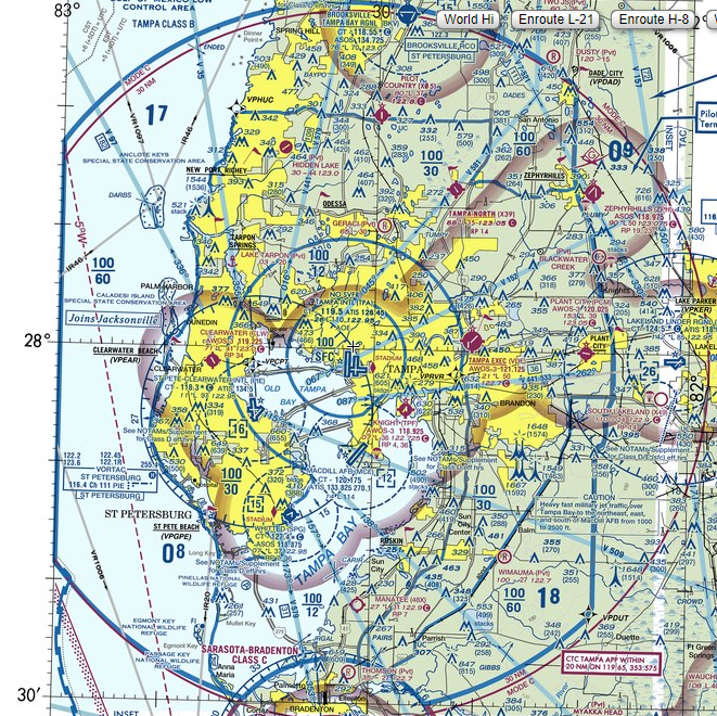

 07-16-2023